Introduction
Property rezoning is a phrase frequently uttered among urban developers, homeowners, and city planners. At its core, rezoning refers to the alteration of the classification of a piece of land, moving it from one designated use to another. For instance, land zoned as 'residential' might be rezoned to 'commercial' or 'mixed-use.' Given the intricate framework of Canada's land use regulations and the economic implications of rezoning, understanding this process is pivotal for anyone involved in property development or land use in the country.
Background & Basics
Canada's vastness and regional diversity have necessitated a nuanced approach to land use planning. While the Indigenous peoples of Canada had their own land use and management systems for millennia, the formal history of zoning in the modern Canadian context traces back to the early 20th century. This was a time when the rise of urban centers and the growth of industries required organized land-use strategies to ensure sustainable development.
Initially, zoning was primarily a tool to separate incompatible land uses, ensuring that industrial facilities didn't spring up in the heart of residential neighbourhoods. However, as cities grew and needs evolved over time, the role of zoning expanded. Today, it serves a variety of social, economic, and environmental objectives.
This brings us to the differentiation between 'zoning' and 'rezoning'. While they sound similar, they address distinct aspects of land use. Zoning is the initial classification of parcels of land into specific categories based on the intended use. For instance, land might be zoned for residential, commercial, or industrial use. These classifications come with sets of regulations determining building types, heights, densities, and more. Rezoning, on the other hand, refers to the process of changing an existing zone classification to another. This often becomes necessary when there's a shift in community needs, economic pressures, or development objectives.
Understanding the types of zones is crucial in this discourse. Here's a quick rundown:
- Residential Zones: These areas are designated primarily for housing. They might further be categorized based on the nature of the housing—single-family homes, multi-family units, or high-rise apartments.
- Commercial Zones: Here, business activities take precedence. Trade thrives in commercial zones, whether it's a bustling retail hub, an office complex, or a neighbourhood store.
- Industrial Zones: As the name suggests, these are areas reserved for manufacturing, processing, and other industrial operations. These zones ensure that potentially disruptive or polluting industries are kept at a distance from residential neighbourhoods.
- Mixed-Use Zones: A relatively modern concept, mixed-use zones allow for a combination of uses, often residential and commercial. They promote walkability and reduce the need for long commutes.
- Special Zones: This could encompass anything from agricultural zones, where farming is the primary activity, to heritage zones that preserve historical landmarks.
Key Reasons for Rezoning

In the realm of urban development, few actions carry as much weight or potential impact as rezoning. Over time, the reasons behind these zoning changes have grown increasingly complex, often influenced by multifaceted challenges and opportunities. Here are some of the primary motivations:
- Changing Land Use Needs and Urban Development Patterns: As cities evolve, their needs shift. A once predominantly residential area might become better suited for commercial activity, or an industrial zone might need to transform into a residential neighbourhood as urban sprawl takes over. With urbanization surging, cities require more housing, businesses, and amenities. To adapt to these shifting urban landscapes, rezoning becomes essential.
- Economic Factors Influencing Rezoning: Economic drivers play a significant role in land use decisions. When cities want to attract specific industries or businesses, they may rezone areas to accommodate these new economic players. Moreover, as property values fluctuate, areas once seen as unattractive for development may suddenly become hotspots. The promise of increased tax revenue or job creation can also spur municipalities to consider rezoning applications favourably.
- Socio-cultural Shifts and their Impact on Land Use: As societal values change, so do our urban landscapes. A heightened focus on sustainability might lead to increased mixed-use zones, promoting walkability and reducing car reliance. An aging population may necessitate more residential zones with proximity to healthcare facilities. Cultural hubs or areas with historical significance might also influence rezoning decisions to preserve and protect them.
Understanding the Legal Framework
Though driven by various needs and factors, rezoning doesn't occur in a vacuum. It's deeply embedded in Canada's legal structure, which provides a roadmap for any rezoning endeavour:
- Overview of the Canadian Land Use Planning System: At its core, Canada's land-use planning system is a shared responsibility. While the federal government has some roles, such as in the case of federal lands or indigenous territories, the bulk of decision-making power resides with provinces and territories. They, in turn, often delegate much of the hands-on land-use planning, including rezoning, to municipalities.
- Role of Provincial and Territorial Legislation: Each province and territory has its legislation guiding land-use planning. For instance, Ontario's Planning Act provides the foundation for most land-use policies in the province. It lays out the procedures for zoning changes, among other things. In British Columbia, the Local Government Act and the Vancouver Charter provide the framework for land use. While each province and territory has its nuances, the common thread is that they set the general guidelines, which municipalities then fine-tune based on local needs.
- The Significance of Municipal Zoning By-Laws: It's at the municipal level that the rubber meets the road. Municipal zoning by-laws provide detailed rules and regulations about what can be built and where. They delve into specifics, setting out permissible building heights, lot sizes, parking requirements, etc. When property owners or developers seek to change a parcel's zoning, they ask the municipality to amend these by-laws. Such amendments aren't taken lightly and usually involve public consultations, expert reviews, and thorough consideration of the broader urban planning goals.
The Rezoning Process: A Step-by-Step Guide
Rezoning is not just about swapping one land use category for another; it's a meticulous process grounded in research, dialogue, and decision-making. Here's a closer look at the journey from inception to culmination:
- Initial Research: Determining Current Zoning and Potential Constraints: This is the foundational step. Property owners or developers need to ascertain the current zoning of the land parcel in question. Municipal websites, land use maps, or direct inquiries can illuminate this. Additionally, it's crucial to identify any constraints or special designations, like floodplains or heritage sites, that could influence the rezoning decision.
- Preliminary Discussions with Municipal Planning Staff: Before diving deep, it's wise to consult informally with the municipal planning department. These preliminary discussions can provide valuable feedback, identify potential hurdles, and offer guidance on how to align the rezoning request with the city's broader planning objectives.
- Pre-Application Consultation and Community Meetings: Some municipalities mandate a pre-application consultation. This structured dialogue allows for a detailed discussion about the proposal, requirements, and potential concerns. Equally vital is engaging with the local community. Hosting community meetings helps gauge neighbourhood sentiment, address concerns, and potentially refine the proposal based on feedback.
- Submitting the Rezoning Application: Necessary Documents and Fees: It's time to formalize the request once the groundwork is done. A rezoning application typically includes detailed site plans, environmental assessments, and traffic impact studies. There's usually an application fee, which varies based on the municipality and project scale.
- Public Hearing Process: Transparency is a hallmark of the rezoning process. Once the application is reviewed, it's presented at a public hearing. This forum allows community members to voice their opinions, ask questions, and present arguments for or against the proposal.
- Decision-making: Approval, Denial, or Modifications: Post the public hearing, the city council or a designated committee convenes to decide the application's fate. They can approve it, reject it, or ask for modifications. This decision is influenced by the application's merits, public feedback, alignment with city planning goals, and any potential socio-economic or environmental impacts.
- Appeals Process: Avenues and Potential Outcomes: Not every decision is met with unanimous agreement. In cases of disagreement, there's usually an avenue to appeal the decision. Depending on the province or territory, this could be through a body like the Local Planning Appeal Tribunal in Ontario. The appeal process re-evaluates the application and the reasons for its initial decision, potentially leading to an overturn or confirmation of the initial verdict.
Key Stakeholders in the Rezoning Process
Rezoning is not an isolated endeavour—it's a collaborative process that involves multiple stakeholders, each bringing a unique perspective and set of interests.
- Municipal Planning Departments: These are the gatekeepers of the rezoning process. They offer guidance, review applications, and ensure proposals align with broader urban planning goals.
- Local Community Members and Neighborhood Associations: The local community's voice is indispensable. After all, they're the ones who'll live with the repercussions of any rezoning decision. Through public hearings, community meetings, and feedback sessions, they offer insights, voice concerns, and shape the trajectory of rezoning applications.
- Developers and Property Owners: These are often the initiators of the rezoning process. Whether looking to develop a parcel of land or sell it for a different use, they navigate the intricate process, balance community feedback with their objectives, and invest time and resources into realizing their vision.
- Environmental and Heritage Organizations (where relevant): In cases where a site has environmental sensitivity or historical significance, these organizations play a pivotal role. They advocate for protecting natural habitats, historic landmarks, or cultural sites, ensuring that development doesn't come at the cost of erasing a piece of nature or history.
Using 3D Rendering in Rezoning Applications: A Modern Approach to Land Use Planning
The arena of rezoning applications, characterized by complex regulations, diverse stakeholders, and often, contentious decisions, is witnessing a transformative shift through the advent of 3D rendering. This technology is not merely about creating aesthetically appealing visuals; it's about offering clarity, precision, and a vision of the future. Let's explore how 3D rendering techniques – from exterior renderings to site plans and the integration with drone photography – are redefining the rezoning landscape.
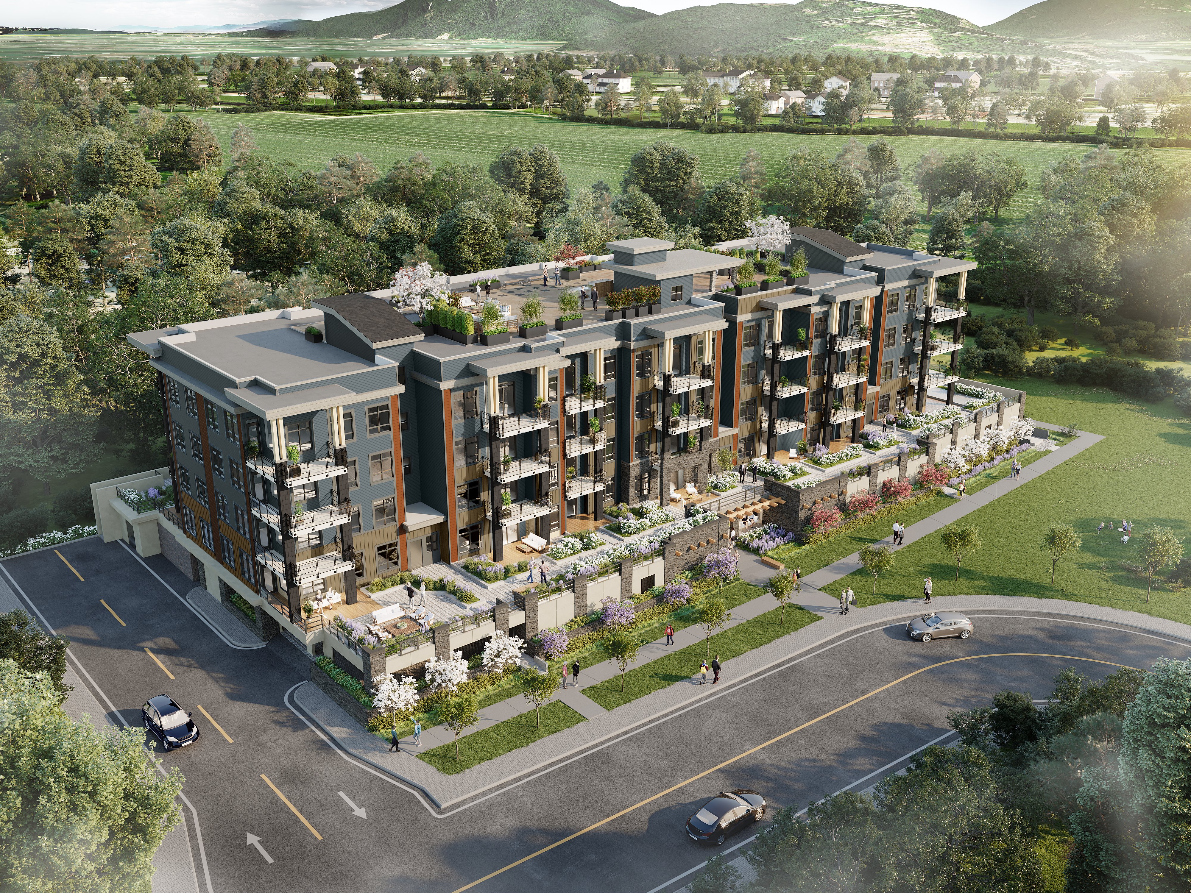
1. Exterior Renderings for Rezoning Applications

- What are Exterior Renderings in this Context? Within the framework of rezoning applications, exterior renderings provide a vivid, three-dimensional depiction of how a proposed development or change will manifest in real life, considering the surrounding environment and the broader urban or rural canvas.
- Advantages:
- Stakeholder Clarity: Unlike traditional sketches or descriptions, exterior renderings present stakeholders with a realistic visualization, allowing them to understand the potential impact and benefits of the proposed rezoning.
- Improved Deliberations: These renderings can be instrumental in decision-making processes for planning commissions and governing bodies, offering a tangible depiction of future scenarios.
- Public Engagement: When introduced during public hearings or consultations, exterior renderings can be practical communication tools, enabling communities to visualize changes, share feedback, and even address potential concerns.
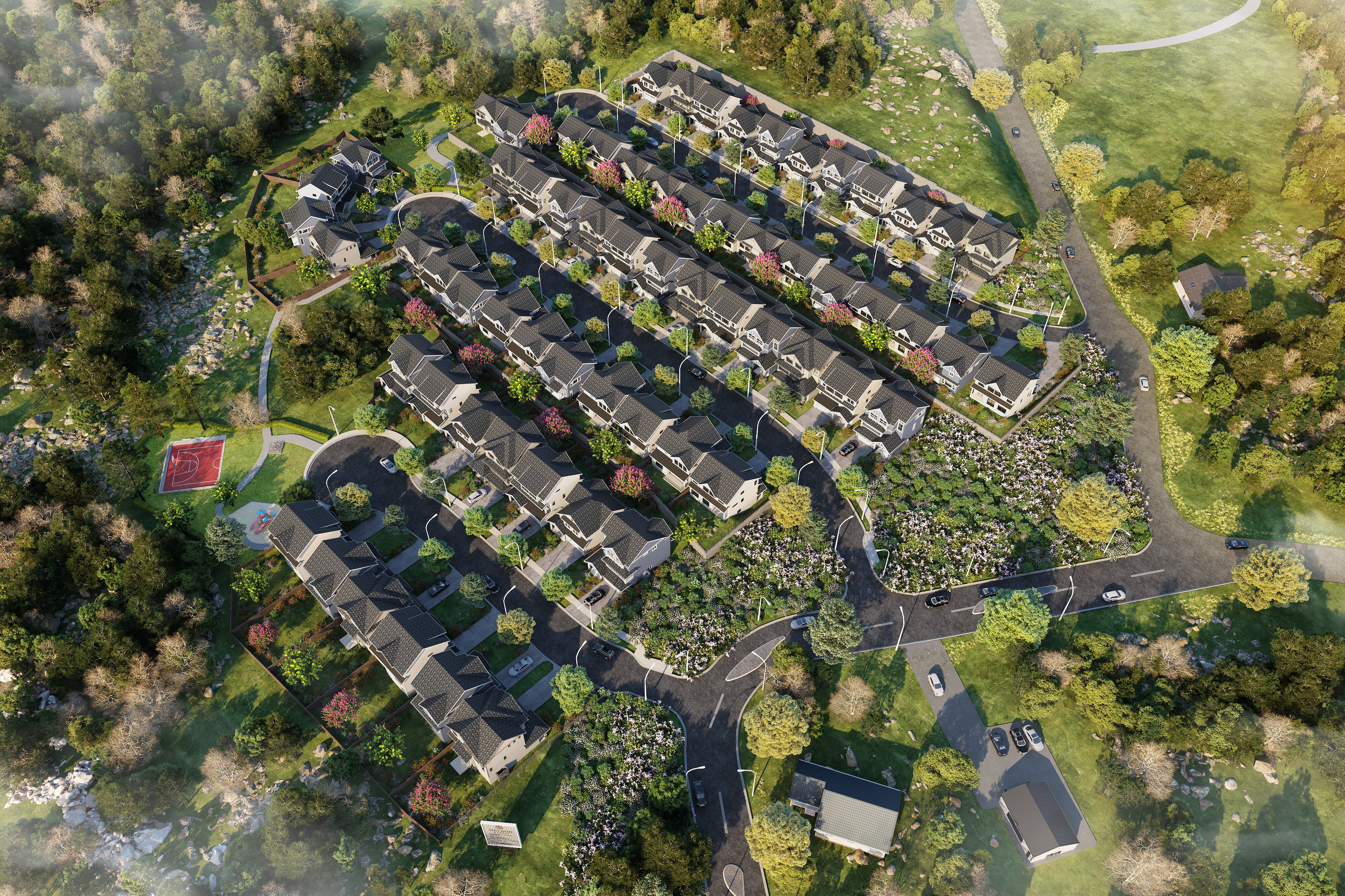
2. Using 3D Site Plans for Rezoning Applications
- The Shift to 3D Site Plans: A 3D site plan transcends traditional flat, 2D site maps. It provides a bird's-eye view of a proposed development in its entirety, capturing topography, structures, landscaping, and even nuances like shadows.
- Merits in Rezoning:
- Holistic Perspective: Whether it's a mixed-use development or a residential enclave, a 3D site plan offers a comprehensive picture of how different elements integrate and interact within a proposed space.
- Technical Details with Visual Appeal: These plans combine the preciseness of architectural blueprints with the allure of 3D visualization, making them accessible yet detailed.
- Facilitating Collaborative Discussions: Beneficial during pre-application consultations, 3D site plans can foster discussions between developers, urban planners, and municipal staff, helping refine rezoning proposals.
3. Merging Renderings with Drone Photography for Rezoning Applications

- What is this Fusion? Here, 3D renderings are seamlessly integrated into aerial photographs taken by drones, juxtaposing the existing environment with the envisioned change post-rezoning.
- Impacts and Advantages:
- Realism at its Best: This method amplifies the authenticity of a rendering. By placing the proposed change within the current environment, stakeholders get a near-real experience of the future.
- Enhanced Stakeholder Buy-in: Especially in contentious rezoning cases, seeing how a proposed development fits within the existing landscape can assuage concerns and foster acceptance.
- Comparative Analysis: This fusion can offer side-by-side comparisons of current scenarios versus potential futures for committees evaluating the implications of a rezoning application.
In the intricate dance of rezoning – where visions of growth, development, and preservation often intertwine – 3D rendering emerges as a potent tool, bridging the gap between imagination and reality. Offering tangible, lifelike depictions enhances understanding, fosters collaboration, and, crucially, provides a window into the future. As rezoning continues to shape tomorrow's urban and rural landscapes, integrating modern visualization tools ensures that these decisions are well-informed, well-received, and well-integrated into the broader tapestry of community development.
Challenges & Common Pitfalls
Property rezoning can often appear as a straightforward venture from the outside. However, it's a path riddled with challenges that demand foresight, preparation, and tactful navigation.
- Navigating Bureaucratic Processes: One of the primary challenges in rezoning lies in understanding and maneuvering through layers of bureaucracy. Each province, territory, and municipality might have its procedures, timelines, and requirements. An overlooked detail or a missed deadline can jeopardize an entire application.
- Managing Community Resistance or Opposition: A rezoning application isn't just about land and people. And where people are involved, there are emotions, opinions, and stakes. Managing community sentiment is vital. A rezoning proposal might seem perfect on paper, but success becomes a tough climb if it's met with strong resistance from local residents. The potential for increased traffic, noise, or a perceived threat to neighbourhood character can galvanize opposition.
- Ensuring Compliance with Environmental and Heritage Regulations: A place's natural and historical essence is invaluable. Overlooking environmental or heritage guidelines isn't just a regulatory misstep—it can tarnish public opinion and result in long-term repercussions. Ensuring that a rezoning application respects these guidelines, and proactively addressing them, is paramount.
Case Studies
Successful Rezoning Application: The Transformation of Toronto's Distillery District
- Background: Once home to the Gooderham and Worts Distillery, this historic area of Toronto had been largely abandoned by the late 20th century.
- The Proposal: Developers saw potential in its Victorian-era architecture and sought to transform it into a mixed-use area, blending retail, art, dining, and cultural spaces.
- Factors Behind Approval: A robust preservation strategy ensured the district's historic buildings remained intact. The proposal also emphasized the creation of public spaces, fostering a sense of community. Effective communication with city officials and residents paved the way for approval.
- Outcome: Today, the Distillery District is a bustling, pedestrian-only area, celebrated for its fusion of history, art, and modern urban living.
Controversial Rezoning Decision: Vancouver's Broadway Corridor Expansion
- Background: As Vancouver grappled with rapid urbanization and housing demands, city planners eyed the Broadway Corridor—a transit-heavy area—as prime for increased density.
- The Proposal: The plan aimed to rezone parts of the corridor to allow taller buildings and higher density, hoping to accommodate more residents and businesses.
- Challenges: The proposal faced stiff resistance. Locals worried about the potential for towering skyscrapers, shadows, and the erosion of the area's character. Environmentalists also raised concerns about the possible strain on local green spaces.
- Lessons Learned: While some degree of rezoning eventually occurred, the backlash underscored the need for a more participatory planning approach. Engaging with communities early on, being transparent about intentions, and being willing to adjust based on feedback are crucial lessons that emerged from the episode.
In the realm of rezoning, there's no one-size-fits-all formula for success. Each proposal unfolds against a unique backdrop of local dynamics, challenges, and aspirations. However, one can tread this path more confidently and clearly by understanding the pitfalls, recognizing the stakes, and learning from real-life scenarios. Whether it's the successful transformation of a historic district or the contentious debates over urban density, these journeys illuminate the complexities and possibilities that define the world of rezoning in Canada.
Future Trends in Property Rezoning

Change is the only constant, especially in the dynamic realm of urban planning and rezoning. As cities grapple with new challenges and tools, here are some emerging trends reshaping the rezoning landscape:
- Impacts of Climate Change on Land Use Planning and Rezoning: As the ramifications of climate change become more palpable, rezoning decisions are becoming intertwined with environmental imperatives. Areas prone to flooding or rising sea levels might face zoning restrictions or need repurposing for conservation. Conversely, cities might prioritize rezoning to encourage the development of green spaces or promote urban farming, enhancing resilience against changing climates.
- The Growing Role of Technology in the Rezoning Process: Technology, particularly Geographic Information Systems (GIS), is revolutionizing how cities approach rezoning. GIS tools allow planners and developers to analyze land use patterns, environmental constraints, and infrastructure in unprecedented detail. Additionally, the pandemic has accelerated the adoption of virtual consultations, making rezoning more accessible and inclusive. Digital platforms enable broader community engagement, transcending physical barriers.
- Shifts towards More Sustainable and Mixed-Use Developments: The sustainability mantra influences all urban life spheres, including rezoning. There's a growing emphasis on creating mixed-use zones, where residents can live, work, and play in proximity. Such zones reduce the carbon footprint associated with commuting, promote walkability, and foster vibrant communities. Future rezoning applications will likely need to align with these sustainable, holistic visions of urban living.
Tips & Best Practices
For those looking to navigate the complexities of rezoning successfully, a few tried-and-tested strategies can make the journey smoother:
- Building Strong Relationships with Municipal Staff: It's not just about paperwork; it's about people. Building a rapport with municipal planning staff can make a world of difference. They're the ones familiar with the intricacies of the process, local challenges, and broader urban visions. Engaging them early, seeking their insights, and treating them as collaborators can set the stage for a smoother rezoning application.
- Engaging the Community Early and Effectively: The community's voice is powerful. Before putting pen to paper, engage the local community. Understand their concerns, aspirations, and visions for the area. Host townhalls, workshops, or even informal coffee chats. Such proactive engagement can preempt potential opposition, refine your proposal, and create a sense of shared ownership over the rezoning process.
- Ensuring Comprehensive Documentation and Research: The devil is in the details. Ensure that every aspect of your rezoning application, from environmental assessments to traffic impact studies, is thoroughly researched and documented. A comprehensive, well-researched application streamlines bureaucratic reviews and establishes credibility in the eyes of decision-makers and the community.
In wrapping up, the future of rezoning in Canada will be a dance between adapting to new challenges and harnessing emerging tools. The road might be complex, but with a keen understanding of evolving trends and a commitment to best practices, it's a journey that can reshape cities for the better. Whether it's crafting resilient urban spaces in the face of climate change or leveraging technology for inclusive decision-making, the future of rezoning beckons with promise and potential.
Conclusion
Land sits at the core of a dynamic, ever-evolving world in all its static nature. Our cities and towns pulse with the rhythm of people, progress, and change, and at the heart of this transformation lies the intricate process of rezoning. As we've journeyed through the myriad facets of rezoning in Canada, a couple of undeniable truths emerge:
- The Importance of Adaptability in Land Use Planning: Cities are living entities, not frozen in time. As such, land use planning cannot be rigid. It requires the fluidity to adapt – to changing climates, technological advancements, economic shifts, and, most importantly, to its residents' evolving dreams and needs. Rezoning is the tool that gives urban spaces this adaptability. By periodically reassessing and recalibrating how land is used, cities can remain relevant, resilient, and responsive.
- The Evolving Nature of Rezoning in the Face of Rapid Urbanization and Changing Societal Needs: The 21st century is witnessing urbanization at an unprecedented scale. As cities burgeon and societal dynamics shift, rezoning isn't just about allocating land parcels; it's about envisioning a future. It's about creating spaces where communities thrive, nature flourishes, and history is revered. It's about imagining cities that are inclusive, sustainable, and poised for growth.
In essence, rezoning is not merely an administrative function. It's a testament to a city's heartbeat, aspirations, and commitment to a brighter, more harmonious future.
Resources & Further Reading
For those looking to delve deeper into the nuances of property rezoning in Canada, here's a curated list of resources:
- Key Legislative Documents and By-laws by Province/Territory:
- Ontario – The Planning Act: Provides the basis for land use planning in Ontario, encompassing rezoning processes.
- British Columbia – The Local Government Act and Community Charter: These documents guide municipal land use planning in BC.
- Quebec – The Planning and Development Act: Central to understanding zoning and rezoning in Quebec.
- Alberta – The Municipal Government Act: This act offers insights into land use planning in Alberta.
- Recommended Books:
- "Land Use Planning Made Plain" by Hok-Lin Leung: An accessible primer on Canadian land use planning.
- "Cities and the Law: Urban Life and Litigation in the Roman World" by J. E. Drinkwater: Offers a historical perspective on urban planning.
- "Planning Canadian Communities" by Gerald Hodge and David L.A. Gordon: A comprehensive look into urban planning in Canada.
- Articles & Online Resources:
- Canadian Institute of Planners – This professional institute provides resources, publications, and guidelines on planning practices in Canada, including rezoning.
- Places to Grow – An initiative by the Ontario government, detailing the province's growth plan, including insights into zoning and land use policies.
- Municipal World – A magazine that often covers land use planning topics, with many articles related to rezoning.
Note: This outline is a foundational guide for an article on property rezoning in Canada. However, as with everything dynamic, it's essential to keep abreast of recent developments, legislative changes, and emerging trends post-2021. Depending on the target audience and the required depth, fine-tuning and updates may be necessary, to ensure the content remains timely, relevant, and engaging.