The Benefits of 3D Aerial Siteplan Renderings
by RealSpace
Siteplan rendering has been at the heart of architectural, construction, and development projects for as long as people have been building. These visual representations, traditionally in two dimensions, painted a clear picture of the intended design, allowing stakeholders to visualize and approve the layout of structures, landscapes, pathways, and other vital elements. Though rudimentary, they served as a blueprint upon which grand structures and intricate designs were brought to life.
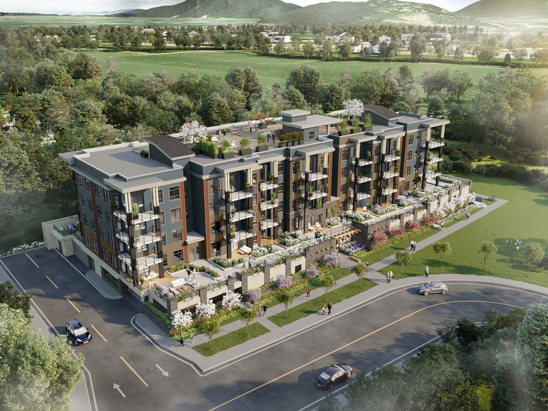
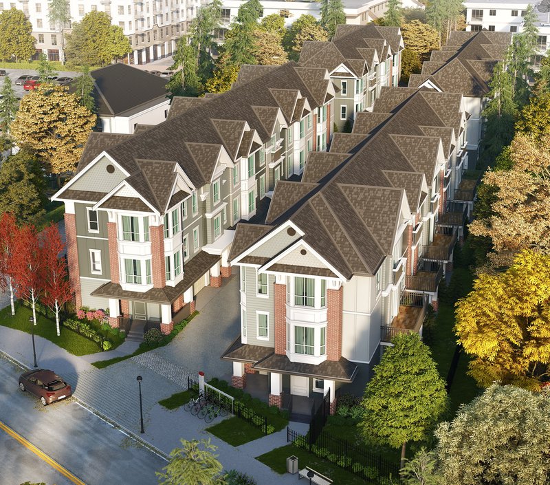
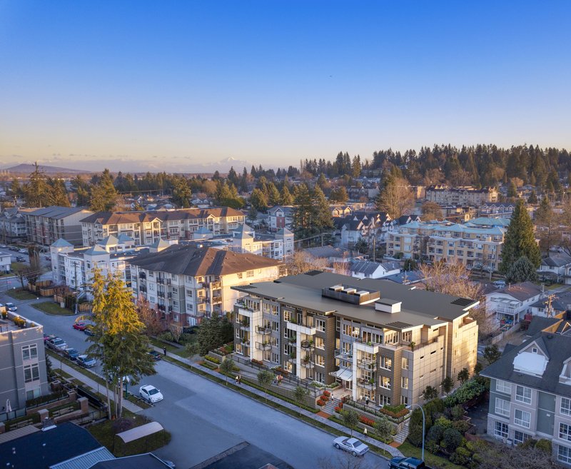
However, as technology has advanced, so has how we visualize and conceive spaces. Enter 3D aerial siteplan rendering —a game-changer in the world of architecture and design. As the name suggests, these renderings offer a three-dimensional perspective, typically from an aerial viewpoint. This fresh approach has taken the industry by storm, offering many advantages over its predecessors. These 3D visuals provide a more detailed and realistic representation of the project and enable viewers to experience a space before it is physically built, revolutionizing stakeholder presentations and marketing endeavours.
Historical Perspective
Journeying back, the earliest site plans were hand-drawn, and crafted meticulously by skilled drafters and architects. These drawings, often on parchment or tracing paper, required a keen understanding of spatial relationships and the talent to translate intricate details into two dimensions. Mistakes, often inevitable when dealing with human hands, were time-consuming to rectify, and the overall process was labour intensive.
The 20th century marked significant strides in rendering techniques with the introduction of computer-generated imaging. Software such as AutoCAD democratized the design process, allowing for swifter modifications and a level of precision previously unattainable. Yet, these computer-assisted designs were primarily 2D, albeit with a more streamlined process.
However, the true revolution arrived with the transition from 2D to 3D rendering. This shift did not merely add a dimension to the visuals; it completely transformed how architects, clients, and stakeholders experienced a project. No longer were they limited to imagining the depth, height, or spatial relationships from a flat drawing. With 3D, a project could be visualized from any angle, whether a bird’s-eye view or a ground-level perspective. And as software became more advanced, so did the realism and detail of these renderings, blurring the lines between virtual representation and reality.
This evolution, from hand-drawn plans to intricate 3D models, mirrors the broader trajectory of technology in our lives. Just as the world has become more dynamic and interconnected, so have the tools we use to envision and create within it.
Defining 3D Aerial Siteplan Renderings
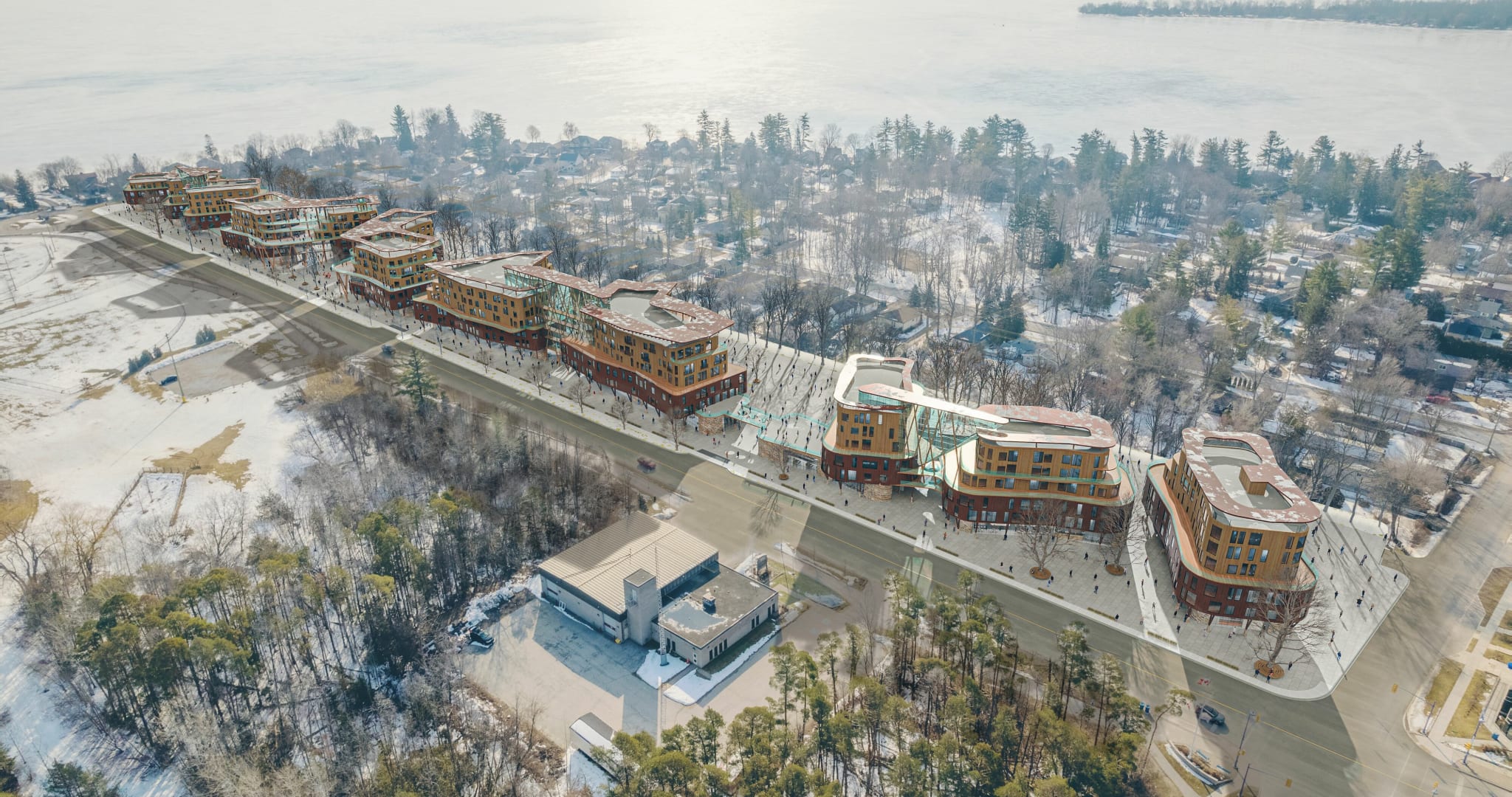
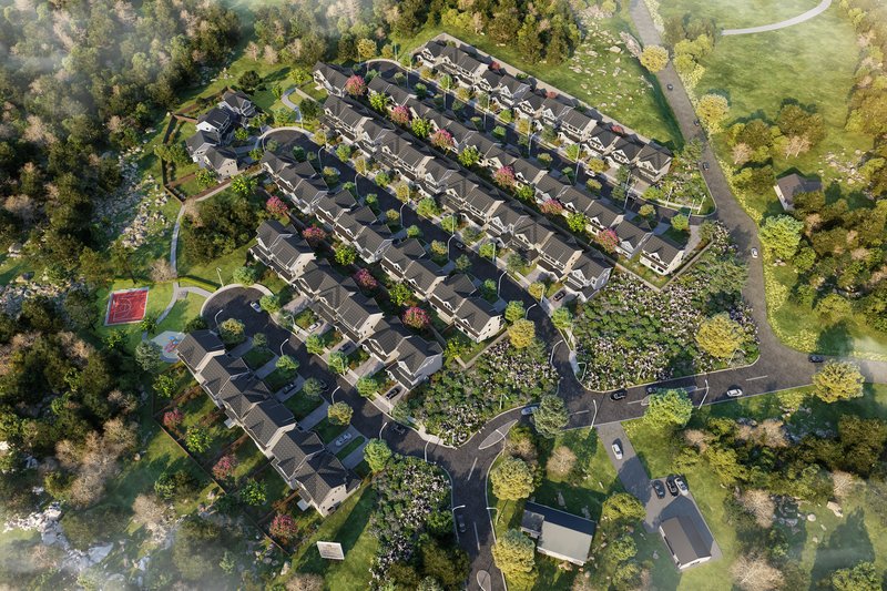
3D aerial siteplan renderings represent a fusion of technology and artistry to provide three-dimensional visuals of a particular site or property from overhead or "aerial" perspectives. In contrast to traditional flat, 2D renderings, these 3D models offer depth, volume, and spatial dynamics, offering a more holistic view of the project.
Central to this innovation is the technology behind it. Advanced software tools have become the backbone of these rendering processes. The architecture and design sectors have widely adopted tools such as SketchUp, Autodesk 3ds Max, and Lumion. These software packages allow professionals to craft intricate models, imbue them with realistic textures, and even simulate real-world lighting and environmental conditions.
Beyond software, the hardware plays a crucial role. Modern workstations equipped with high-end graphics cards, ample RAM, and fast processors ensure that the rendering process is smooth and detailed. With virtual reality (VR), there's an increasing emphasis on hardware compatibility to create immersive experiences using these 3D models.
Visual Appeal and Realism
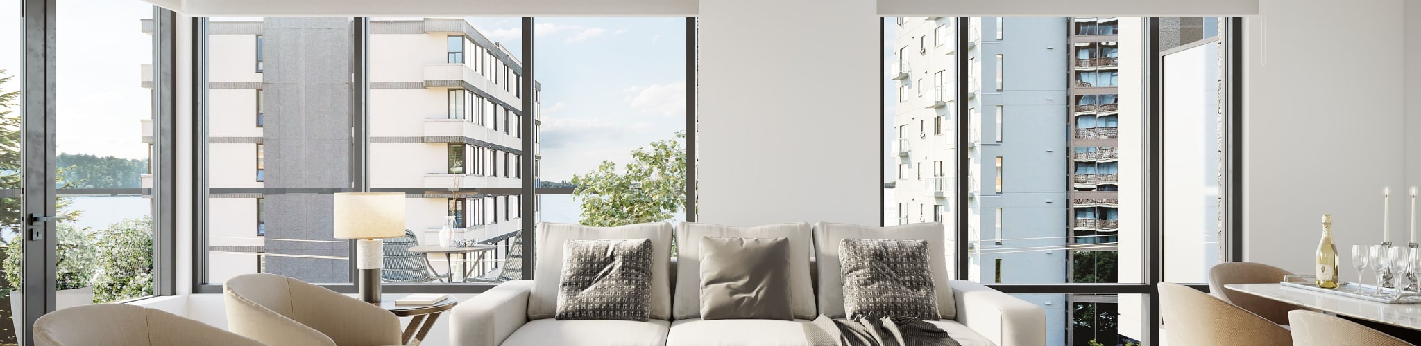
In a world where first impressions often dictate decisions, the photorealistic edge of 3D aerial siteplan renderings cannot be overstated. Traditional 2D plans, while functional, couldn't capture the imagination or provide a genuine feel of the proposed structure or space. In contrast, 3D renderings spring to life, presenting an almost real-world representation of the intended design.
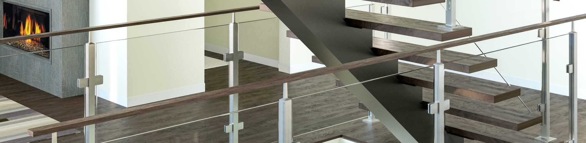
One of the standout features of these renderings is the heightened texture portrayal. Every minute detail can be meticulously crafted from the grain of the wood, the roughness of bricks, to the reflection on glass surfaces. This attention to texture, combined with accurate depth portrayal, adds a tangible feel to the project, making it easier for stakeholders to connect with the design.
The dynamic use of lighting and shadows elevates these renderings to another level. Lighting can be manipulated to showcase how a particular space will look at different times of the day or under specific conditions. Shadows, too, are accurately cast, depending on light sources, making the rendering more authentic. Such elements make the project more visually appealing and allow for better planning, as they reveal how natural light will interact with the structure, influencing both design and functional considerations.
3D aerial siteplan renderings are more than just advanced visuals. They are a bridge between vision and reality, offering a lens through which we can preview the future of our architectural endeavours.
Enhanced Stakeholder Communication
One of the most significant challenges in the realm of architecture and construction has always been effective communication. Given the complexity and scale of projects, ensuring everyone is on the same page is paramount. 3D aerial siteplan renderings offer a tangible solution, redefining how architects, clients, and other stakeholders interact and understand the vision behind a project.
Bridging gaps between architects, clients, and stakeholders
With their specialized training and experience, architects can easily interpret and visualize 2D plans. However, clients and other stakeholders may not share this level of expertise. A conventional plan's intricate lines, symbols, and notations can mystify the untrained eye. In this context, misunderstandings can arise, leading to misaligned expectations or costly revisions.
3D aerial renderings, however, offer a more intuitive way to convey design intent. Stakeholders can more easily grasp the architect's vision by providing a three-dimensional, realistic view of the project. This visual clarity streamlines discussions, ensures everyone's expectations align, and reduces the chances of miscommunication. It's akin to giving stakeholders a sneak peek into the future, offering them a tangible glimpse of the project's outcome.
Facilitating clearer visualization of proposed structures and landscapes
The value of clear visualization in architecture cannot be overstated. For clients, seeing is believing. While architects have the training to construct spaces from 2D plans mentally, clients typically need something more tangible. 3D aerial renderings serve this very purpose.
These renderings don't just show structures; they breathe life into them. Presenting a design in its environmental context gives stakeholders a comprehensive view of the project. This includes how buildings sit within a landscape, how pathways weave through a site, or how communal areas interact with private spaces. Such a holistic perspective empowers stakeholders to make informed decisions, whether it's about aesthetics, functionality, or spatial efficiency.
Simplifying complex design concepts
Every project comes with its unique set of challenges and innovations. An architectural solution might sometimes involve complex design concepts, novel materials, or innovative spatial configurations. Conveying these ideas effectively using traditional methods can be daunting.
With 3D aerial siteplan renderings, such complexities become easier to digest. For instance, if an architect proposes a green roof with integrated solar panels, a 3D rendering can showcase how it looks, how it fits into the building's design, and its potential benefits. Similarly, complex interior spatial arrangements, which might seem abstract in a 2D plan, become palpable and easy to understand.
These renderings can be interactive. Stakeholders can explore different sections, toggle between various design alternatives, or even visualize how spaces might be used in different scenarios. This interactive element further simplifies intricate designs, allowing stakeholders to immerse themselves fully in the project.
In conclusion, 3D aerial siteplan renderings are not just technological advancements but a communication revolution. By providing realistic, holistic, and interactive visuals, they ensure that architects' visions are conveyed accurately, clients' expectations are met, and every stakeholder's input is valued. In an industry where clarity can save time, money, and resources, these renderings are proving to be invaluable.
Improved Project Efficiency and Accuracy
In a world where first impressions often dictate decisions, the photorealistic edge of 3D aerial siteplan renderings cannot be overstated. Traditional 2D plans, while functional, couldn't capture the imagination or provide a genuine feel of the proposed structure or space. In contrast, 3D renderings spring to life, presenting an almost real-world representation of the intended design.
One of the standout features of these renderings is the heightened texture portrayal. Every minute detail can be meticulously crafted from the grain of the wood, the roughness of bricks, to the reflection on glass surfaces. This attention to texture, combined with accurate depth portrayal, adds a tangible feel to the project, making it easier for stakeholders to connect with the design.
The dynamic use of lighting and shadows elevates these renderings to another level. Lighting can be manipulated to showcase how a particular space will look at different times of the day or under specific conditions. Shadows, too, are accurately cast, depending on light sources, making the rendering more authentic. Such elements make the project more visually appealing and allow for better planning, as they reveal how natural light will interact with the structure, influencing both design and functional considerations.
3D aerial siteplan renderings are more than just advanced visuals. They are a bridge between vision and reality, offering a lens through which we can preview the future of our architectural endeavours.
Enhanced Stakeholder Communication
One of the most significant challenges in the realm of architecture and construction has always been effective communication. Given the complexity and scale of projects, ensuring everyone is on the same page is paramount. 3D aerial siteplan renderings offer a tangible solution, redefining how architects, clients, and other stakeholders interact and understand the vision behind a project.
Bridging gaps between architects, clients, and stakeholders
With their specialized training and experience, architects can easily interpret and visualize 2D plans. However, clients and other stakeholders may not share this level of expertise. A conventional plan's intricate lines, symbols, and notations can mystify the untrained eye. In this context, misunderstandings can arise, leading to misaligned expectations or costly revisions.
3D aerial renderings, however, offer a more intuitive way to convey design intent. Stakeholders can more easily grasp the architect's vision by providing a three-dimensional, realistic view of the project. This visual clarity streamlines discussions, ensures everyone's expectations align, and reduces the chances of miscommunication. It's akin to giving stakeholders a sneak peek into the future, offering them a tangible glimpse of the project's outcome.
Facilitating clearer visualization of proposed structures and landscapes
The value of clear visualization in architecture cannot be overstated. For clients, seeing is believing. While architects have the training to construct spaces from 2D plans mentally, clients typically need something more tangible. 3D aerial renderings serve this very purpose.
These renderings don't just show structures; they breathe life into them. Presenting a design in its environmental context gives stakeholders a comprehensive view of the project. This includes how buildings sit within a landscape, how pathways weave through a site, or how communal areas interact with private spaces. Such a holistic perspective empowers stakeholders to make informed decisions, whether it's about aesthetics, functionality, or spatial efficiency.
Simplifying complex design concepts
Every project comes with its unique set of challenges and innovations. An architectural solution might sometimes involve complex design concepts, novel materials, or innovative spatial configurations. Conveying these ideas effectively using traditional methods can be daunting.
With 3D aerial siteplan renderings, such complexities become easier to digest. For instance, if an architect proposes a green roof with integrated solar panels, a 3D rendering can showcase how it looks, how it fits into the building's design, and its potential benefits. Similarly, complex interior spatial arrangements, which might seem abstract in a 2D plan, become palpable and easy to understand.
These renderings can be interactive. Stakeholders can explore different sections, toggle between various design alternatives, or even visualize how spaces might be used in different scenarios. This interactive element further simplifies intricate designs, allowing stakeholders to immerse themselves fully in the project.
In conclusion, 3D aerial siteplan renderings are not just technological advancements but a communication revolution. By providing realistic, holistic, and interactive visuals, they ensure that architects' visions are conveyed accurately, clients' expectations are met, and every stakeholder's input is valued. In an industry where clarity can save time, money, and resources, these renderings are proving to be invaluable.
Environmental Analysis and Integration
In the contemporary world of architecture and construction, environmental considerations have moved from the periphery to the core of design processes. Sustainable practices demand innovative materials and technologies and a profound understanding of how structures integrate with their surrounding ecosystems. Today's tools, especially those used in 3D aerial siteplan renderings, bring forth capabilities that significantly enhance environmental analysis and integration.
Assessing environmental impact with more precision
Traditional design processes, while insightful, often presented a limited perspective on a project's environmental footprint. With sophisticated 3D modelling and simulation tools, architects and planners can now dissect and analyze how their designs interact with the environment in unparalleled detail.
For instance, energy consumption predictions can be more accurately produced by analyzing how a structure's design might interact with its climatic context. Whether it's the passive solar benefits of a particular window placement or the thermal advantages of a specific insulation choice, designs can be optimized to reduce their carbon footprint.
Beyond energy, these tools can aid in water management strategies, ensuring optimal rainwater harvesting or drainage, and even reducing light pollution in urban environments.
Real-time simulations: sunlight, rainwater flow, wind patterns
One of the crowning achievements of modern design tools is the ability to simulate environmental interactions in real-time. This dynamic analysis offers insights that static models or plans could never provide.
Consider sunlight simulation. Architects can model how sunlight filters into a building at different times of the day and year. Such simulations can influence decisions about window placement, shading devices, or even room orientations, ensuring maximum natural light benefits while reducing overheating risks.
Rainwater flow simulations provide insights into how water will move across a site. This can inform landscaping decisions, ensuring optimal water absorption, and minimizing runoff. It also aids in planning drainage systems, ensuring they are not overburdened during heavy rainfall or under-used.
Wind patterns, too, can be simulated to gauge how they'll interact with a structure. This can influence design elements to ensure that outdoor spaces are comfortable, not akin to a wind tunnel or that buildings are oriented to take advantage of natural ventilation strategies.
Better landscaping and environment integration plans
A structure isn't an island; it exists in harmony (or discord) with its surroundings. Modern tools allow for the creation of landscaping plans that are not just aesthetically pleasing but also environmentally synergistic.
Using 3D aerial siteplan renderings, architects can visualize how green spaces, water bodies, pathways, and other landscape elements integrate with the built environment. This allows for designs where green roofs reduce urban heat islands, strategically placed trees offer shade and reduce energy consumption or water features that add aesthetic value and aid in micro-climate regulation.
These tools allow for integration strategies that enhance local biodiversity. For instance, selecting native plants that support local fauna or creating habitats that attract beneficial insects, birds, or even aquatic life.
In sum, environmental analysis and integration have been elevated to a new level with today's technological capabilities. It's no longer about merely reducing a building's negative impact on the environment; it's about ensuring that structures, landscapes, and ecosystems exist in a mutually beneficial symphony. In an age where sustainability is not just desired but essential, these tools and methodologies are guiding the architectural world towards a future where designs harmonize with, rather than dominate, their natural surroundings.
Cost Benefits
Every architectural project necessitates a balancing act between upfront investments and long-term financial outcomes. Integrating 3D aerial siteplan renderings into the design and presentation processes might seem like an additional expenditure. Still, a closer look reveals many avenues where they lead to considerable savings.
Upfront investment versus long-term savings
While the initial costs of acquiring the software and training for 3D aerial siteplan renderings might seem steep, the investment pays off manifold in the project's subsequent phases. Advanced visualization aids in identifying potential design flaws or inefficiencies early on, negating expensive changes during construction. When stakeholders can visualize a project in its entirety, decisions are made faster, reducing the time and costs associated with prolonged deliberations.
Reduction in physical model costs
Before the digital revolution, physical models were a staple in architectural presentations. Creating these models was not only time-consuming but also expensive. 3D renderings, with their intricate details and realistic portrayals, have reduced the reliance on these physical models. While there might still be situations where they are warranted, many firms find digital renderings sufficient, leading to significant cost savings.
Reduced design revision costs due to improved clarity
Design revisions are inevitable. However, with clearer visualization tools at hand, the frequency and amount of these revisions are drastically reduced. When clients and stakeholders can virtually walk through a space, their feedback is more precise, and the chances of last-minute or drastic changes diminish. This clarity, brought about by 3D aerial siteplan renderings, directly translates to reduced design revision costs.
Promotional and Marketing Advantages
Standing out is paramount in the highly competitive realms of real estate and architecture. 3D aerial siteplan renderings, beyond their design and presentation functionalities, have emerged as potent marketing tools, offering firms distinct advantages.
Using 3D aerial siteplan renderings in promotional material
The appeal of realistic, detailed visuals in marketing cannot be overstated. Whether it's brochures, online listings, or even billboards, incorporating 3D renderings grabs attention. These visuals allow potential buyers or clients to visualize the final product, making the promotional material more engaging and persuasive.
Enhanced marketability for real estate and architectural firms
In an era where clients and investors often start their search online, presenting them with static 2D plans is hardly enticing. However, dynamic 3D renderings, especially those that offer interactive experiences, can set a firm apart. For real estate ventures, it can mean attracting potential buyers; for architectural firms, it can be the difference between clinching a project or not. The enhanced marketability these renderings offer is invaluable in today's digital age.
Attracting investors and clients with impressive visuals
First impressions matter. When pitching a project to investors or presenting a design to potential clients, the impact of high-quality 3D renderings is unparalleled. They offer a clear, detailed, and immersive view of the project, allowing investors and clients to visualize the end product. Such clarity and realism can decide when securing investments or approvals.
In conclusion, while the functional benefits of 3D aerial siteplan renderings are clear in the design and construction processes, their potential as promotional and marketing tools is equally significant. In a visual-driven world, they offer firms an edge, ensuring they resonate with their target audiences more effectively and persuasively.
Challenges and Considerations
While the benefits of 3D aerial siteplan renderings are many, integrating them into standard practice isn't without challenges. Several considerations arise for firms transitioning from traditional methods or those looking to upgrade their tools.
The learning curve associated with new software
Transitioning to any new software comes with an inherent learning phase. For professionals accustomed to traditional design methods or even simpler digital tools, mastering the intricacies of advanced 3D rendering software can be daunting. Training sessions, continuous practice, and perhaps even a period of dual-system use might be needed before full proficiency is achieved.
Hardware investments and requirements
3D rendering, especially when involving complex projects with high levels of detail, demands robust hardware capabilities. This might mean investing in high-performance workstations, graphics cards, and ample storage. Such investments can be significant, especially for smaller firms or freelance professionals.
Importance of skilled professionals for quality rendering
A tool is only as good as its user. Quality renderings demand proficiency in software and a deep understanding of design principles, lighting, textures, and more. As a result, hiring or training professionals who can harness the software's full potential becomes crucial.
Future of 3D Aerial Siteplan Renderings
The trajectory of technological advancements in architecture shows an exciting future for 3D aerial siteplan renderings.
Integration of augmented reality (AR) and mixed reality (MR)
Beyond the confines of screens, AR and MR promise to bring 3D renderings to life in our immediate environment. Imagine clients wearing AR glasses that overlay a proposed structure onto a vacant site, allowing them to visualize it in real-time and real space. Such immersive experiences will revolutionize client presentations, stakeholder engagement, and even on-site construction guidance.
Predictions for how this technology might evolve and its growing importance in the architectural and real estate sectors
As computational capabilities grow and software becomes more sophisticated, the detail, realism, and functionalities of 3D aerial siteplan renderings are bound to expand. Future renderings may simulate material aging, seasonal changes, or even integrate AI to suggest design optimizations.
These advancements will drive precision, efficiency, and stakeholder satisfaction for the architectural sector. They promise enhanced sales tools for the real estate sector, with potential buyers experiencing properties in previously considered science-fiction ways.
As urban environments grow complex and the emphasis on sustainable practices intensifies, the ability to visualize and analyze designs in their ecosystem context will become invaluable. This might mean renderings that simulate decades of environmental interactions or tools that offer real-time feedback on sustainability metrics.
While 3D aerial siteplan renderings are transformative today, the horizon suggests they're merely the precursors of even more revolutionary tools to come. Their importance in shaping the built environment of tomorrow cannot be overstated.
Conclusion
The metamorphosis of architectural and real estate visualization through 3D aerial siteplan renderings is not just a technological progression but a paradigm shift. From their historical evolutions to the transformative impact they have on today's industries, the advantages they offer span across design accuracy, stakeholder communication, environmental integration, cost savings, and marketing prowess.
Beyond the tangible benefits, these renderings underscore a broader theme in our contemporary world: the convergence of creativity and technology. They embody the epitome of this convergence, where the left-brained precision of software meets the right-brained creativity of design. This blend facilitates not only aesthetically pleasing visuals but also robust, sustainable, and efficient designs that cater to today's pressing needs.
Yet, as with any technological advancement, the onus falls upon industries and professionals to adapt proactively. Hesitation or reluctance can lead to missed opportunities and stagnation. The architectural and real estate sectors stand at a juncture where the tools to redefine their practices are available. It's a call to move beyond traditional comfort zones, embrace the transformative potential of these tools, and deliver results that cater to an ever-evolving audience.
This journey, however, shouldn't be seen as a destination. The rapid pace of technological advancement suggests that today's innovative tools may be the norms of tomorrow. Continuous innovation, therefore, becomes imperative. Whether it's integrating augmented reality, leveraging AI insights, or venturing into realms yet unknown, the field is ripe with opportunities.
To every stakeholder in these sectors — be it a seasoned architect, a budding designer, a real estate mogul, or an innovative startup — the message is clear: the future is not just about envisioning and creating structures but about redefining the very tools and processes that enable such creation. Adapt, embrace, innovate, and let's collectively shape an environment that resonates with the needs and aspirations of tomorrow.