Visualizing Density: Using 3D Rendering to Optimize Livability in Urban Architecture
by RealSpace
Urban architecture and city planning play a monumental role in creating habitable, functional, and livable cities. Amid this, urban density — the concentration of people and structures in an area — is a pressing concern. On the one hand, high-density can maximize resource efficiency, encourage public transportation use, and foster vibrant cultural and social hubs. Without thoughtful planning and design, density can lead to overcrowding, traffic congestion, and decreased quality of life. Hence, the challenge for architects and city planners is not only to accommodate growing populations and urbanization but also to do so in a manner that enhances the livability of urban environments.
This is where 3D rendering, an innovative technology tool, comes into play. It allows architects and urban planners to create three-dimensional visualizations of their designs before construction begins, offering an opportunity to model and optimize both urban density and livability coherently and tangibly. Through 3D rendering, architects can explore various design iterations, engage more effectively with stakeholders, and ultimately make better-informed decisions about the layout, structure, and design of urban spaces.
This article explores the transformative role of 3D rendering in optimizing urban density while enhancing livability. We delve into the intricacies of urban density and livability, unravel the power of 3D rendering in architectural design, and examine how this technology is used to visualize and balance urban density and livability. Through real-world case studies, we shed light on the successful application of 3D rendering in urban architecture, and how it navigates the potential challenges and shapes the future of urban planning and design.
In the grander scheme of things, this article underscores the pivotal role that technology and innovative tools like 3D rendering can play in shaping sustainable, efficient, and livable cities of the future. Let us embark on this journey of exploration and discovery to understand how we can use 3D rendering to create better urban environments that balance the needs for density and livability in harmony.
Understanding Urban Density and Livability
Urban density refers to the number of people living within a specific urban area or the number of structures in a space. It is a crucial factor in urban planning and architecture, as it directly impacts the overall structure of a city and the quality of life of its residents. High-density urban areas often display a greater variety of amenities, such as shops, restaurants, and cultural facilities, within walking distance. These areas have better public transportation networks because of higher demand.
However, high urban density can also lead to many challenges if not properly managed. These include overcrowding, lack of privacy, noise pollution, strain on infrastructure, traffic congestion, and potentially, a decrease in the quality of life for residents. Therefore, achieving an optimal balance between high and low density is critical to creating livable urban spaces.
Livability pertains to the quality of life experienced by inhabitants of a city. Several factors contribute to a city's livability, including the availability of quality housing, efficient transportation systems, access to green spaces, air and water quality, safety, cultural and recreational amenities, and inclusivity. A livable city is one that not only meets the basic needs of its residents but also enhances their well-being and happiness.
The Power of 3D Rendering in Architectural Design
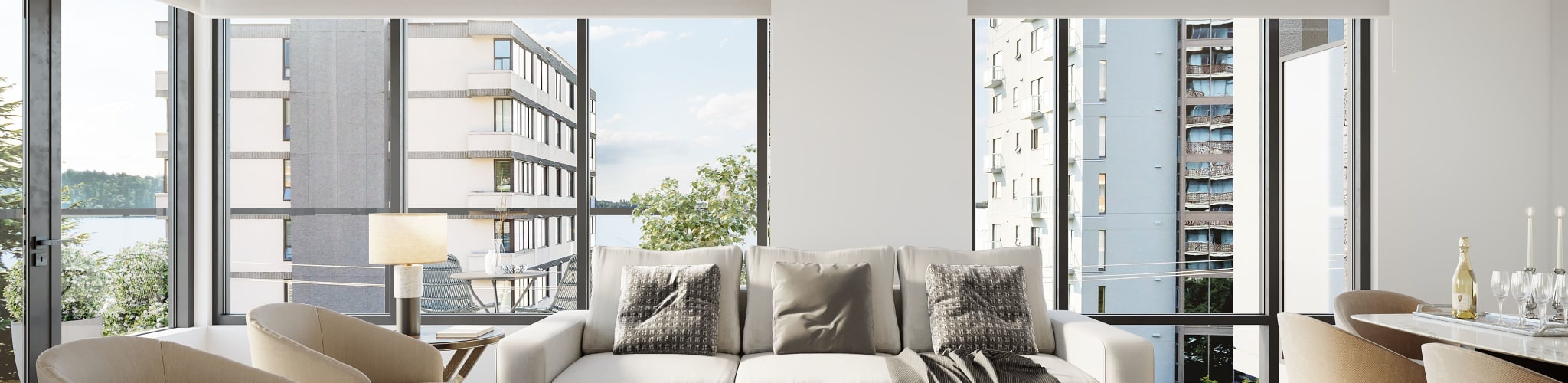
3D rendering is an advanced technology that uses computer graphics to convert 3D models into 2D images or animations. In architecture and urban planning, 3D rendering is an invaluable tool for visualizing and communicating design concepts. It allows architects to create lifelike representations of their designs, complete with textures, lighting, and landscape elements, providing a holistic view of the proposed project.
This technology has many advantages. For one, it enables architects and urban planners to experiment with different design solutions in a risk-free environment. They can change their designs, try out different material combinations, and see the effects of these changes instantly, with no costly and time-consuming physical models or mock-ups.
3D renderings can engage stakeholders, including city officials, investors, and the public. By offering a realistic visualization of the proposed project, these renderings can help stakeholders better understand the project, its benefits, and its potential impact on the urban environment. This can facilitate discussions, stimulate feedback, and promote consensus around the project.
Visualizing Urban Density and Livability with 3D Rendering
3D rendering can serve as a powerful tool for modelling and optimizing urban density and livability. By creating detailed, three-dimensional visualizations of urban spaces, architects and urban planners can examine how different levels of density affect the physical layout of the city, the availability and use of amenities, and the overall quality of life of the residents.
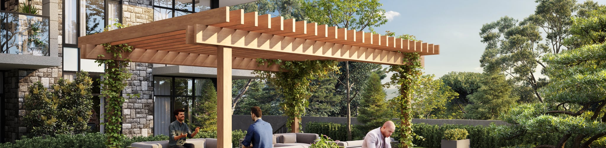
For instance, a 3D rendering of a high-density residential area can show how the careful arrangement of buildings can create a sense of community while maintaining privacy for individual households. Similarly, it can show how the incorporation of green spaces, walking paths, and bike lanes can enhance the livability of the area, even with a high concentration of structures.
3D rendering can simulate different lighting conditions, weather scenarios, and traffic patterns, providing a more comprehensive understanding of how urban density and design elements interact under various circumstances. This ability to visualize and assess the complex interplay of urban density and livability realistically and holistically makes 3D rendering an indispensable tool in urban architecture and planning.
Through the subsequent sections of this article, we will delve deeper into real-world case studies that showcase the successful application of 3D rendering in visualizing and optimizing urban density and livability. We will explore the potential challenges encountered in this process and discuss how 3D rendering technology is shaping the future of urban planning and design. Ultimately, we will understand how 3D rendering can help us build sustainable, efficient, and livable cities of the future.
Case Studies: Successful Application of 3D Rendering in Urban Planning
Let's delve into the real-world application of 3D rendering technology by examining several case studies where it played a pivotal role in visualizing and optimizing urban density and livability.
Case Study 1: Revitalizing an Urban Core
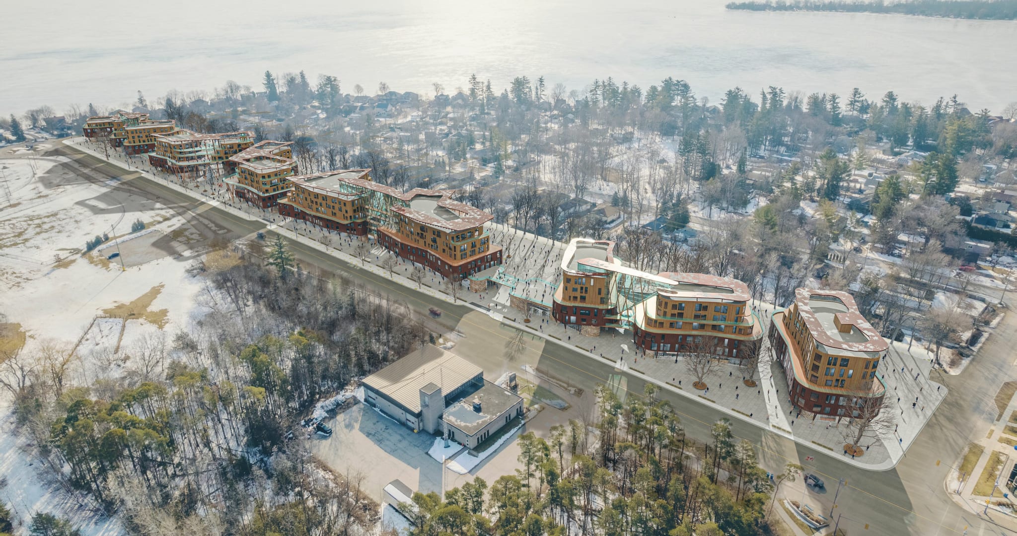
The first case study is from a city planning project in Boston, where a run-down district was marked for redevelopment. The major challenge was to increase the urban density while maintaining a high level of livability for current and future residents.
Using 3D rendering technology, the urban planning team could visualize different scenarios of housing mix, layout, and amenity distribution. By simulating pedestrian flow, sunlight distribution, and visual privacy, the team optimized the design to balance the increased density and livability factors. The 3D renderings played a significant role in communicating the design to stakeholders, facilitating consensus, and driving the project towards successful completion.
Case Study 2: Creating a Sustainable Suburb
The second case is from a suburban development in Melbourne, where the city aimed to reduce urban sprawl while creating a sustainable and livable residential area. The project demanded a careful blend of medium to high-density housing, efficient public transportation, and an abundance of green spaces.
3D rendering was used to create an immersive model of the proposed suburb, complete with energy-efficient houses, a public transport network, and a variety of green spaces. The 3D model allowed planners to evaluate and fine-tune the design in terms of urban density, transportation efficiency, access to amenities, and other livability factors. The realistic representation also enabled effective communication with residents and decision-makers, smoothing the path for the project's approval and execution.
Case Study 3: Planning a Mixed-Use District
The third case study involves the planning of a mixed-use district in Singapore that accommodates commercial buildings, residential apartments, cultural institutions, and recreational spaces within a limited area. The goal was to create a vibrant urban hub without compromising the quality of life.
Through 3D rendering, the planners could visualize the interactions between different uses and assess the impact on density and livability. By altering building heights, orientation, spacing, and the allocation of public spaces, they could create a design that balanced high density with high livability. The 3D renderings helped to illustrate the vision for the district, gaining stakeholder buy-in, and refining the design in response to feedback.
These case studies illustrate how 3D rendering can be a powerful tool in tackling the challenges of urban density and livability. It enables architects and urban planners to visualize complex urban environments, explore and evaluate different design solutions, and communicate their ideas effectively to a broad range of stakeholders.
The Future of 3D Rendering in Urban Planning
Looking forward, the role of 3D rendering in urban planning and architecture is expected to grow. As cities continue to grapple with the dual challenge of increasing urban density and enhancing livability, 3D rendering will become an ever more critical tool in the urban planner's toolkit. The realistic and holistic visualization it provides will aid in understanding the complexities of urban environments and developing innovative and sustainable solutions.
With advancements in technology, 3D rendering is becoming more accessible and user-friendly. Architects and planners can now create high-quality 3D renderings on their computers with no specialized knowledge or expensive hardware. This democratization of 3D rendering technology will further speed up its adoption and impact on urban planning and architecture.
In conclusion, 3D rendering offers enormous potential in visualizing and optimizing urban density and livability. By enabling a holistic view of urban environments, it can help architects and planners create more sustainable, efficient, and livable cities for the future. As we embrace this technology, we are not just designing buildings and cities - we are shaping the future of urban life.
The Power of 3D Rendering: Community Engagement and Consensus Building
One of the significant challenges in urban planning is to gain acceptance from local communities and stakeholders for fresh developments, especially when these involve increasing density. This is where 3D rendering can play a unique and powerful role.
3D rendering can create immersive visualizations that allow residents and stakeholders to see and understand proposed changes to their environment. By demonstrating how the design can enhance livability, these visualizations can help address concerns, stimulate constructive dialogue, and build consensus.
Let’s consider a case where a city is planning to redevelop a historical district by adding high-rise apartments and commercial buildings. This is a sensitive matter, as it could change the neighbourhood's character, possibly leading to opposition from residents. However, using 3D renderings, planners can illustrate how they will maintain the district's historical charm while adding new amenities and creating a more vibrant community. They can show how the high-rises will be integrated with the existing architecture, where the shadows will fall at different times of the day, and how public spaces will be enhanced. This clear communication can help assuage residents' concerns and garner their support for the project.
Improving Design and Decision-Making Through 3D Rendering
3D rendering can also contribute to improved design and decision-making processes in urban planning. With 3D visualization, architects and planners can better understand the implications of their design choices, enabling them to optimize the balance between density and livability.
For instance, they can experiment with different layouts, building heights, and orientations to see how these affect sunlight penetration, ventilation, and views. They can assess how different mixes of uses — such as residential, commercial, and recreational — affect the vibrancy and functionality of an area. They can evaluate how varying the distribution and design of public spaces influence pedestrian flow and social interactions. All these insights can guide them in refining their designs to achieve the best outcomes.
3D renderings can support better decision-making by providing a solid basis for evaluating and comparing different design options. Instead of relying on abstract plans and technical specifications, decision-makers can see and understand the real-world implications of different options. This clarity can lead to more informed and confident decisions, and ultimately, to better urban environments.
Conclusion: A Vision for Livable Density
Cities around the world are facing the challenge of increasing urban density while enhancing livability. This is a complex task that requires innovative thinking, sensitive design, and effective communication. As this article has shown, 3D rendering can be a powerful tool in this endeavour.
By creating realistic and holistic visualizations, 3D rendering can enable architects and planners to explore, understand, and optimize the complex interplay of factors that determine urban density and livability. It can help communicate proposed changes effectively to residents and stakeholders, fostering understanding, dialogue, and consensus. And it can support improved design and decision-making, leading to better urban environments.
As we navigate the complex path toward livable density, 3D rendering will be a valuable ally, shedding light on our choices and helping us create cities that are dense, livable, and ready for the future.